
Boating
Boating in Homosassa Florida is a privilege that shouldn’t be taken for granted. We are fortunate to be able to enjoy all the beauty that this area possesses. From the magnitude of all the underground springs to the excitement of harvesting scallops in the bay on a hot summer day. From the ability to fish an immense area teaming with a huge variety of species to the amazing sounds of the huge family of bird life that frequents our skies. Let’s all use common sense and become familiar with the basics of boating in our area.
 Safe Boating Precautions
US Coast Guard Equipment
Boat Speed Zones
Public Boat Ramps
Marinas
Artificial Reefs
Protecting Manatees
Protecting Seagrass
Native Habitats
Safe Boating Precautions
Every year hundreds of people are killed or injured in boating accidents in Florida. Most of these accidents could have been prevented if those involved exercised some basic boating safety precautions. Below are some safety precautions that responsible boaters take to make sure that their trip will be safe and enjoyable.
Observe and obey posted speed limits. When in doubt, slow down.
Watch your wake. Remember, you are responsible for damage caused by your vessels wake. Large wakes can overturn smaller vessels and damage personal property.
Use nautical charts in unfamiliar waters. Stay within marked channels.
Learn and use all boat navigational rules.
Plan your trip in advance. Use the appropriate nautical charts to reference depth, bridge clearance and other possible encounters before you leave.
File a float plan with a responsible person outlining your expected route and estimated time of return.
Do not operate a boat recklessly or under the influence of drugs or alcohol.
Wear your life jacket and make sure you have enough life jackets for all persons on board.
Monitor the weather through visual observation and the NOAA weather radio at 162.55 MHz VHF.
Have a written storm preparation plan. Prepare 48 hours early for tropical storms and hurricanes.
Enroll in a safety boating course. Contact Boat/U.S. Foundation at 800-336-BOAT or contact the FWC at http://www.floridaconservation.org/
US Coast Guard Equipment**
Personal floatation device (PDF’s) must be available for each person on board. Children under 6 years of age are required to wear their life jacket on boats less than 26 feet long.
Fire Extinguisher is recommended on all power boats, and manadatory on certain vessels. Keep your fire extinguisher fully charged.
Sound Signaling Device – Vessels under 39 feet must cary a whistle, horn or other attention-getting device. Boats over 39 feet require both a whistle and a bell.
Visial Distress Signals – Various combinations of flares are used. A mirror is another excellent signaling device.
**The operator of a boat (owned, rented or borrowed) is responsible for having all the USCG required equipment onboard and in good working condition. Different sized vessels may require additional safety equipment. Contact the FWC Law Enforcement or US Coast Guard for more information.
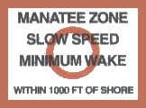
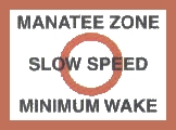
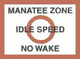
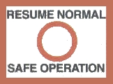
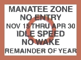
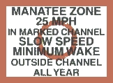
Boat Speed Zones
Speed zones are abundant in the Homosassa and Crystal River due to the large populaion of Manatees. These zones are marked with signs in and along the waterways. Some examples of signs you might see are:
 |
 |
 |
 |
 |
 |
Idle Speed – No Wake is the minimum speed that will maintain steerage of the vessel while producing no wake.
Slow Speed – Minimum Wake is the speed at which the baot is operating off-plane and settled in the water while preceeding with little or no wake.
Manatees are protected by the Marine Mammal Protection Act of 1972, the Endangered Species Act of 1973 and the Florida ManateeSanctuary Act of 1978. It is illegal to kill, wound, hunt, shoot, harm, harass, annoy or disturb manatees. The state of Florida has also established a number of cautionary and regulatory speed zones to protect the manatee and its habitat. Please obey all manatee protection laws! Click here for more information about manatees.
What boaters can do…
- Wear polarized sunglasses while operating a boat.
- Be alert to signs of manatee presence such as swirls, or the tip of the snout breaking the water when surfacing to breath.
- Stay within marked channels. Avoid shallow grass beds where manatees feed and rest.
- Follow all posted speed zones and caution signs. Manatees move slowly and have trouble evading boats at higher speeds.
- DO NOT ENTER a manatee sanctuary for any reason. Designated manatee sanctuaries are closed to all waterborne activities including fishing.
- DO NOT FEED, PURSUE or CHASE manatees while boating or swimming. This is defined as harassment and is against the law.
- Stow your trash and retrieve any discarded fishing line and hooks. Manatees can be injured or killed by swallowing plastic debris or becoming entangled in abandoned monofilament or trap line.
- Report injured, dead or tagged manatees to the FWC Law Enforcement at 1-888-404-FWCC or VHF Channel 16, and to the Chassahowitzka National Wildlife Reserve.
Protecting Seagrass
Seagrass is a vital nursery and feeding area for fish and other marine animals. Please protect them!
- Do not operate your boat in areas that are too shallow for your equipment.
- Use nautical chartsand tide tables to plan your course.
- Never cut through seagrass beds with a propeller. Watch your prop wash for mud or plant life which may indicate you are too shallow. Remember prop scars take years to recover!
- Pole or use a trolling motor when traveling across fishing flats. Quiet fishermen catch more fish.
- If you run aground, turn off your engine! Raise the motor and push or pole your way to deeper water. If necessary, wait for high tide to move your boat.
- Do not crowd another boat. If you see another boat fishing on the flats, do not approach unless beckoned.
Seagrasses are flowering underwater plants that form expansive grass beds in the shallow coastal waters of Citrus County. Seagrass beds provide nursery grounds for many commercially and recreationally important species… including fish, crabs, shrimp, and scallops who can hide among the blades and feast upon decaying leaves. Seagrasses also help stabalize the bottom sediments and improve water quality by trapping fine sediments and particles.
Seagrasses can be destroyed by a host of human activities. For example seagrasses need light to produce their own food through photosynthesis, but increased amount of sediments and nutrients in runoff from developed and agricultural land have clouded waters and reduced the light available to seagrasses. Careless boating activity has also damaged grass beds. Propellers carve muddy trenches through these shallow areas, which may then stay barren for years.
Salt Marshes, which are composed of salt-tolerant rushes, sedges, and grasses, occur along the shoelines of estuaries in Citrus County, where wave action is minimal. These marshes, which routinely become submerged, nourish and protect many fish and animals.They also help buffer upland areas from storms and filter pollutants that run off the land. Swamps and marshes store the floodwaters from heavy rains and slowly release them into streams, rivers and bays. Dense growth along estuary shorelines helps to absorb the force of rising waters and wave energy during storms, and the extensive root systems bind the soil, thus helping prevent erosion.
Hardbottom habitats are composed of solid, exposed rock substrate or rubble. They are of low-relief and often covered with a thin layer of sediment. Hardbottom habitats support numerous species of soft corals, stony corals, macroalgae, sponges, and other marine life. The crevices and solution holes in hardbottom habitats offer necessary refuge to many juvenile organisms. Fishes, crabs and turtles commonly reside and feed in hardbottom areas.
Mangroves are tropical trees that have adapted to living at the edge of the marine environment and can be found along the Citrus County coastline. Mangrove roots anchor shorelines, and their branches serve as nesting sites for a wide variety of birds. They form the basis of the detrital food chain and provide nutrition and cover for many fish and other marine organisms. In order to protect mangroves, state and federal regulations restrict their pruning and removal.
Three species of mangroves can be found in Citrus County. Red mangroves, typically located closest to the water, are easily distinguished by their tangled reddish prop roots that branch out over the water. Black mangroves have numersous finger-like projections, called pneumatophores, around the base of the tree, which are used for gas-exchange. White mangroves often occupy the highest elevations of the three species and have no visible root system.